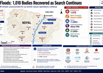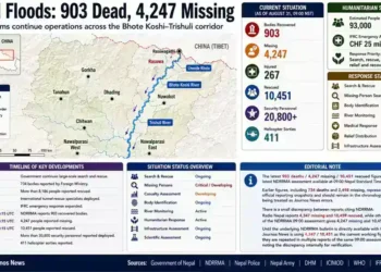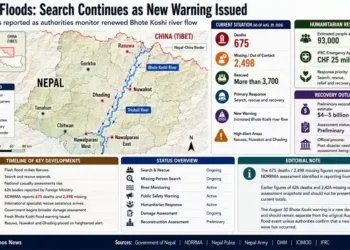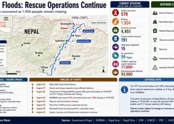
Nepal’s August 26, 2026 disaster began with a massive ice-rock avalanche high in the Himalayas and rapidly developed into a destructive flood and debris-flow emergency. The catastrophe exposed how mountain instability, narrow river valleys and concentrated infrastructure can combine to turn a single geological event into a national humanitarian and reconstruction crisis.
Nepal’s catastrophic flood did not begin as an ordinary monsoon disaster.
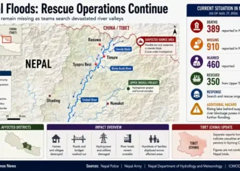
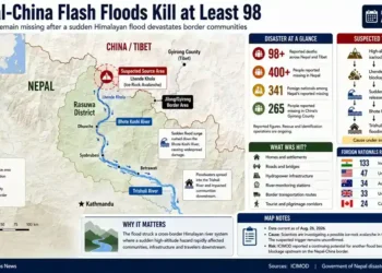
On the morning of Aug. 26, an ice-rock avalanche occurred high in the upper Bhote Koshi watershed near the Nepal-China border. Nepal’s National Disaster Risk Reduction and Management Authority, or NDRRMA, said preliminary analysis based on high-resolution satellite imagery indicated that an estimated one-square-kilometre section of rock-glacier material detached from a north-facing slope near the Lhende River.

As the collapsing mass moved downslope, it incorporated additional loose sediment and developed into a highly mobile mixture of ice, rock, water and debris. The resulting flow entered the river system and became a catastrophic downstream flood.
The consequences extended far beyond the mountain slope where the disaster began.
Communities were destroyed or isolated. Roads and bridges disappeared. Hydropower facilities were buried or inundated. Thousands of people were killed or remained unaccounted for as rescue operations continued into September.
The latest figures have continued to change as authorities recover bodies and reconcile missing-person records. Reuters reported on Sept. 4 that more than 1,250 people had been killed and more than 4,200 remained missing, while other same-day reports cited higher figures as the disaster assessment evolved. Nepal’s disaster authority estimated preliminary losses to property, housing and infrastructure at about 387.5 billion Nepalese rupees, or roughly $2.56 billion.
The disaster is therefore still unfolding in two ways: physically, as rescuers continue searching damaged valleys and underground tunnels, and administratively, as Nepal attempts to establish the full human and economic cost.
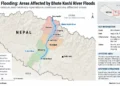
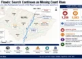
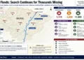

The Disaster Began High in the Himalayas
The initial event occurred approximately 20 kilometres upstream of Rasuwagadhi near the Nepal-China border.
According to NDRRMA’s Sept. 1 situation report, satellite analysis identified a north-facing slope near the Lhende River as the apparent source of the avalanche. An estimated one-square-kilometre section of rock-glacier material detached and moved rapidly downhill, entraining loose proglacial sediment along its path.
That distinction is central to understanding the disaster.
The event was not simply a period of heavy rainfall causing an already swollen river to overflow. It began with a major mass movement involving ice and rock. As that material travelled, it incorporated sediment and water and developed into a debris-rich flow capable of moving enormous quantities of material downstream.
NDRRMA said preliminary assessments suggested the resulting outburst flood exceeded normal seasonal flooding in the upper watershed by an order of magnitude or more.
A strong seismic signal was also recorded near the Langtang-Lirung area. Subsequent analysis indicated that the signal was produced by the mass movement itself rather than by an earthquake that triggered the avalanche, according to NDRRMA and reporting on the event.
The precise geological sequence that caused the initial collapse remains under investigation.
From Mountain Collapse to River Disaster
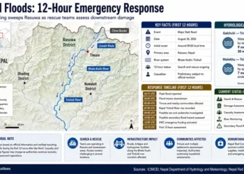
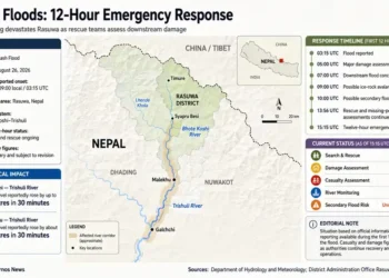
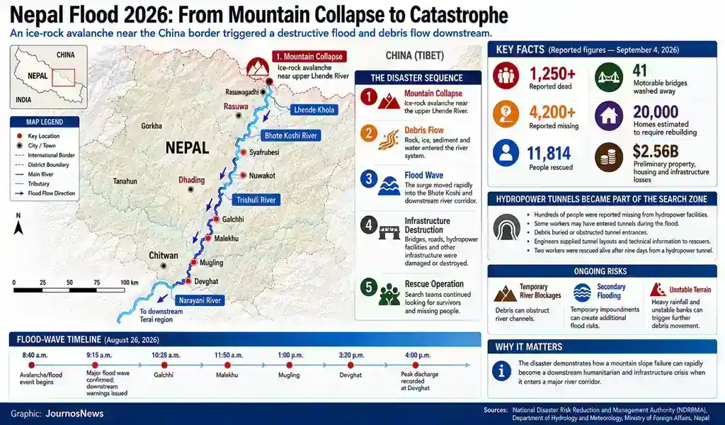
At approximately 8:40 a.m. on Aug. 26, the ice-rock avalanche affected the Lhende Khola and generated a major flood and debris flow that entered the Bhote Koshi River.
The Bhote Koshi-Syafrubesi hydrological station stopped transmitting data at around 8:50 a.m., with its final recorded water level at 1.62 metres, according to NDRRMA.
By 9:15 a.m., Nepal’s Department of Hydrology and Meteorology had confirmed a major flood wave and issued warnings for downstream communities.
NDRRMA reconstructed the downstream movement of the flood through the wider river system, reporting that the surge reached Galchhi at approximately 10:28 a.m., Malekhu at 11:50 a.m., Mugling at around 1 p.m. and Devghat at about 3:20 p.m.
At Devghat, the peak discharge was estimated at approximately 5,850 cubic metres per second. NDRRMA estimated the total flood volume at 57.4 million cubic metres, including nearly 20 million cubic metres of excess water above base flow.
Authorities said hundreds of thousands of warning messages were distributed through Nepal’s telecommunications networks.
Yet warnings could not remove the physical danger posed by a rapidly moving flood travelling through narrow mountain valleys filled with settlements, roads, bridges and major energy infrastructure.
A Narrow River Corridor Amplified the Damage
The affected river corridor is one of considerable strategic and economic importance to Nepal.
It includes border infrastructure near Rasuwagadhi, communities along the river valleys, transport routes and a concentration of hydropower facilities.
NDRRMA described Rasuwa as particularly vulnerable because of steep terrain, active geological conditions and critical infrastructure concentrated within narrow valleys.
That geography can magnify the consequences of a major mountain collapse.
When water, rock and sediment enter a confined river corridor, there is limited space for the flow to spread. The force can instead move downstream through channels bordered by infrastructure and settlements.
The disaster also generated secondary hazards.
NDRRMA reported that temporary lakes formed where debris and sediment blocked river channels. Although some had drained, authorities warned that further temporary impoundments could form because of unstable banks, continuing obstruction and rainfall.
The emergency therefore did not necessarily end when the first flood wave passed.
River blockages, sudden releases of impounded water, additional debris movement and rainfall-triggered flooding remain part of the wider risk environment.
Communities Were Cut Off
The destruction rapidly became an access and humanitarian crisis.
NDRRMA reported that thousands of households remained isolated in parts of Rasuwa days after the flood, with road access, electricity and communications disrupted.
Its Sept. 1 situation report said 3,702 households representing 14,461 people remained isolated in Gosaikunda and Amachhodingmo rural municipalities. The affected population included thousands of children and more than 1,200 older people.
The authority also reported that 41 motorable bridges had been washed away and another four damaged.
That infrastructure loss has consequences beyond the initial destruction.
Roads and bridges determine whether rescue teams can reach isolated communities and whether food, medicine, fuel, communications equipment and engineering machinery can be delivered.
In mountainous terrain, the loss of a single bridge can effectively sever an entire community from the surrounding region.
The Search Became a Race Against Time
Nepal’s search and rescue operation expanded as the scale of the disaster became clearer.
NDRRMA reported more than 11,000 people had been rescued by Sept. 1. Nepal and international partners deployed helicopters, heavy equipment, temporary bridges and specialised rescue resources to reach communities cut off by damaged infrastructure.
But the missing remained the central challenge.
Search teams were not only examining riverbanks and destroyed settlements. They were also investigating debris fields, damaged buildings and major hydropower facilities.
Some of the most difficult searches moved underground.
Hydropower Tunnels Became a Second Disaster Zone
The Bhote Koshi and Trishuli corridors contain a major concentration of Nepal’s hydropower infrastructure.
Reuters reported that roughly 900 workers were missing from six hydropower projects, including facilities where some workers were believed to have taken refuge inside tunnels as the flood struck. Other reporting has produced different estimates of the number of potentially trapped workers as authorities continue to verify who was present at individual facilities.
The flood deposited an estimated 2.2 million tonnes of mud and debris across the affected valley, according to Reuters, making some tunnel entrances difficult to locate and reach.
At Rasuwagadhi, rescuers reached approximately 250 metres into a tunnel before encountering a blockage, while authorities believed dozens of people could be trapped in underground sections. Searches also continued at the Chilime facility.
The problem was not simply one of excavation.
Rescuers needed to understand damaged tunnel networks that were no longer easily recognisable from the surface.
Reuters reported that a WhatsApp group involving more than 500 engineers became part of the rescue effort, with participants sharing plant layouts, technical drawings and tunnel information to help search teams reconstruct underground structures.
The disaster transformed hydropower engineering knowledge into a critical component of the rescue operation.
Two Survivors Changed the Search
Nine days after the disaster, rescuers pulled two workers alive from a tunnel at the Upper Trishuli 3A hydropower facility.
Reuters and the Associated Press reported that the rescue offered evidence that survival remained possible in at least some underground spaces despite the extraordinary conditions.
The operation also reinforced the decision to continue searching other tunnel systems.
Rescue teams had spent days attempting to reach buried or blocked entrances. In some areas, teams worked to identify cavities and possible refuge spaces while engineers attempted to establish the layout of damaged facilities.
The discovery of survivors, however, did not establish that other missing workers were alive.
Each tunnel presented different conditions, different damage patterns and different access problems.
For families waiting for information, that uncertainty remains one of the defining features of the disaster.
Nepal’s Energy System Was Also Hit
The flood damaged a significant concentration of hydropower facilities.
Reuters reported that the disaster affected roughly 10% of Nepal’s power-generation capacity.
That creates a separate reconstruction challenge.
Housing, roads and bridges must be rebuilt. Electricity generation and transmission infrastructure must also be assessed, repaired or reconstructed.
Hydropower facilities are complex industrial systems requiring structural inspections, debris removal and tunnel assessments before operations can safely resume.
The disaster has therefore become simultaneously a humanitarian emergency, an infrastructure crisis and a disruption to Nepal’s energy sector.
The Reconstruction Bill Is Coming Into Focus
Nepal’s preliminary estimate of the disaster’s economic impact stood at approximately 387.5 billion Nepalese rupees, or $2.56 billion, according to Reuters and the head of NDRRMA.
The figure remains preliminary.
Authorities have said a more detailed assessment will be required to establish the full cost of damage to homes, roads, bridges, hydropower projects and other infrastructure.
Reuters reported that Nepal estimated around 20,000 homes would need to be rebuilt, including at least 7,500 destroyed houses.
The government also estimated that approximately $52.6 million would be needed during the first four months of early recovery for priorities including roads, temporary shelters, drinking water and electricity restoration.
Those figures describe the beginning of recovery rather than its final cost.
Why This Was More Than a Conventional Flood
NDRRMA characterised the event as a multi-hazard emergency.
The sequence began with an ice-rock avalanche.
The avalanche generated a debris-rich flow.
The flow entered a river system.
The river carried the flood downstream.
Debris blocked channels and created temporary impoundments.
Roads and bridges were destroyed.
Hydropower infrastructure became both a disaster site and a potential refuge for trapped workers.
This sequence explains why the event cannot be understood simply as a conventional seasonal flood.
A warning system focused only on rainfall and river levels may not provide sufficient lead time when the initiating event is a sudden mountain collapse.
Nepal’s warning systems did distribute large numbers of downstream alerts after the flood wave was identified. But the broader challenge is detecting a sudden high-mountain failure, understanding its likely consequences and communicating warnings rapidly enough to communities located downstream.
What the Disaster Reveals About Himalayan Risk
The catastrophe has highlighted the interconnected nature of risk in Himalayan river valleys.
Narrow corridors often contain the same infrastructure that makes mountain regions economically accessible: roads, settlements, trade routes and hydropower projects.
That concentration can also create vulnerability.
When a major slope failure enters a river, the consequences can travel well beyond the point of collapse.
The Aug. 26 disaster does not yet provide a final scientific explanation for why the avalanche occurred. Authorities and researchers continue to examine the initiating event.
What is already documented, however, is the close relationship between the mountain landscape, the river system and the infrastructure built along it.
Future risk assessments may therefore need to consider hazards as connected systems rather than isolated events.
The Human Emergency Continues
Casualty and missing-person figures have continued to change as rescue teams reach damaged areas and authorities reconcile records.
That uncertainty is itself part of the disaster.
Families are still searching for missing relatives. Communities remain affected by destroyed infrastructure. Some survivors have lost homes and livelihoods, while others have been cut off by damaged roads and bridges.
The continuing tunnel searches have created another layer of uncertainty because some missing workers may have survived the initial flood underground.
The rescue of two workers nine days after the disaster demonstrated that survival was possible in at least one location.
It did not provide an answer for everyone else.
What Happens Next
Nepal’s immediate priorities remain search and rescue, humanitarian assistance, restoration of access and identification of the missing.
Recovery will require far more than emergency relief.
The government faces the task of rebuilding homes, restoring roads and bridges, repairing water and electricity systems and assessing the future of damaged hydropower facilities.
Authorities must also continue monitoring the affected river systems for unstable banks, debris movement and temporary blockages that could create further flood risks.
Reconstruction will therefore involve difficult decisions.
Rebuilding infrastructure exactly as it existed before the disaster may not address the vulnerabilities exposed by the flood.
The challenge will be to restore communities while accounting for the hazards that remain.
What Remains Unresolved
Several fundamental questions remain open.
The precise geological mechanisms behind the initial mountain collapse are still under investigation.
The final death toll and number of missing people remain subject to continuing verification.
The total economic cost has not been established.
The condition and long-term recoverability of damaged hydropower facilities remain under assessment.
The possibility of secondary hazards, including further debris movement and temporary river blockages, has not disappeared.
The continuing tunnel searches are especially significant.
The survival of two workers for nine days showed that rescue teams could not assume the absence of survivors simply because of the time that had passed.
But each additional search location presents a different technical and physical challenge.
Conclusion
Nepal’s Aug. 26 catastrophe began with a mountain collapse near the China border and rapidly developed into a much larger river disaster.
An ice-rock avalanche detached from a high-altitude slope, incorporated additional sediment and generated a destructive debris-rich flood that entered the Bhote Koshi and then moved through wider river systems.
The flood damaged communities, roads, bridges and major hydropower facilities. It isolated populations and created one of the largest search operations Nepal has faced in recent years.
The human toll remains under active assessment, with more than 1,250 deaths and thousands of missing people reported in the latest Sept. 4 accounts. Preliminary damage to property, housing and infrastructure was estimated at approximately $2.56 billion.
Yet the story is not finished.
Rescuers are still searching damaged valleys and underground tunnels. Families are still waiting for information. Communities require restored access and basic services. Nepal faces a reconstruction challenge involving housing, transport and energy infrastructure.
The two workers rescued alive after nine days provided a measure of hope. They also demonstrated why the search has continued.
The most important way to understand the disaster may be as a chain of connected events:
Mountain collapse. Debris flow. River surge. Infrastructure destruction. Community isolation. Prolonged rescue.
That chain transformed a high-altitude geological event into a national catastrophe.
And until the missing are accounted for, damaged communities regain access and the affected river corridor is stabilised and rebuilt, Nepal’s disaster remains unfinished.
Reporting Credit: Government of Nepal Ministry of Foreign Affairs, National Disaster Risk Reduction and Management Authority (NDRRMA), Department of Hydrology and Meteorology (DHM), International Centre for Integrated Mountain Development (ICIMOD).
Sources: Government of Nepal Ministry of Foreign Affairs; National Disaster Risk Reduction and Management Authority; Department of Hydrology and Meteorology; International Centre for Integrated Mountain Development.