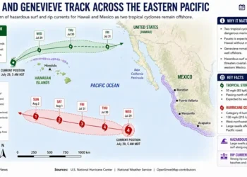
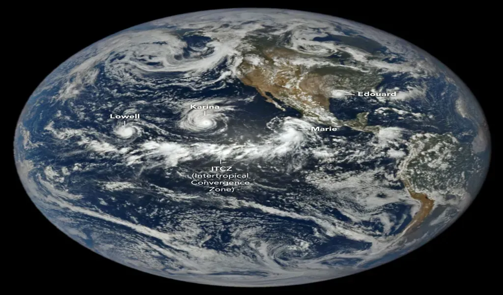
NASA is tracking three hurricanes simultaneously across the Pacific, with new satellite observations showing Lowell, Karina and Marie active across the basin at the same time.
NASA’s Earth Observatory published imagery on Sept. 4 showing the three hurricanes spread across the Pacific, while NASA Earthdata released a separate satellite image from Sept. 2 capturing the systems simultaneously. The observations offer a broad view of an unusually concentrated period of tropical cyclone activity in the region.
The activity comes as eastern-Pacific ocean and atmospheric conditions favor tropical cyclone development, with NASA linking the heightened activity in part to the ongoing El Niño climate pattern.

Three Hurricanes Active Across the Pacific
Lowell, Karina and Marie developed in late August and early September, according to NASA Earthdata. The satellite imagery shows the three systems at different stages while occupying separate areas of the Pacific basin.
Seeing three organized tropical cyclones simultaneously across the same ocean basin provides a regional perspective that individual storm forecasts cannot always capture.
The systems are also spread across a large area, meaning the presence of three hurricanes does not by itself indicate that all three pose an immediate threat to populated areas.
El Niño Creates Favorable Conditions
NASA has linked heightened eastern-Pacific tropical activity to El Niño conditions.
El Niño warms portions of the equatorial Pacific and changes atmospheric circulation, creating conditions that can support tropical cyclone development in the eastern and central Pacific. Warmer ocean temperatures, greater atmospheric moisture and reduced wind shear can help storms organize and intensify.
■ Related News
The same climate pattern can affect other ocean basins differently. In the Atlantic, El Niño is generally associated with stronger vertical wind shear, which can make hurricane development more difficult.
Satellite Observations Reveal Storm Structure
The latest imagery demonstrates the role of Earth-observing satellites in monitoring tropical systems across vast areas of open ocean.
NASA Earthdata said its Sept. 2 image was produced using observations from the Visible Infrared Imaging Radiometer Suite aboard NOAA-21. The infrared imagery captured Lowell, Karina and Marie simultaneously as they moved through the Pacific.
Such observations give scientists and forecasters information about storm organization, movement and changes in structure that can complement operational weather monitoring.
Pacific Activity Reflects Broader Seasonal Conditions
The three-storm cluster comes amid an active period for tropical cyclones in the eastern Pacific during 2026.
NASA reported in August that the eastern Pacific had already experienced elevated tropical cyclone activity, consistent with atmospheric conditions associated with El Niño.
The latest satellite observations provide another snapshot of those broader conditions, showing multiple organized systems developing across the basin at the same time.
Atlantic Conditions Point in a Different Direction
The Pacific activity contrasts with expectations for the Atlantic hurricane season.
NOAA has maintained a forecast for a below-normal Atlantic hurricane season, with El Niño identified as one factor contributing to conditions less favorable for Atlantic hurricane formation.
The contrast highlights how a large-scale climate pattern can affect different tropical cyclone basins in different ways rather than producing uniformly higher activity worldwide.
Storm Tracks Determine Immediate Risk
The presence of three hurricanes does not mean that all three systems are threatening populated areas.
Their potential impacts depend on storm intensity, movement and changes in surrounding atmospheric conditions. Systems that remain over open water can pose risks primarily to maritime operations, while those approaching land can create threats to coastal communities.
Operational weather agencies remain responsible for issuing forecasts, watches and warnings as individual storm tracks develop.
NASA Offers a Basin-Wide Perspective
Satellite imagery allows NASA to document tropical weather systems across areas of the Pacific that are difficult to observe directly.
NASA’s Earth Observatory and Earthdata programs use satellite observations to examine changes in the atmosphere and oceans as well as broader Earth-system processes. The latest imagery provides a near-simultaneous view of three major tropical systems within the same basin.
That perspective helps place individual storms within the larger environmental conditions influencing their development.
Three Hurricanes Highlight Pacific El Niño Pattern
The simultaneous presence of Lowell, Karina and Marie provides a visible snapshot of the broader atmospheric and oceanic conditions affecting the eastern Pacific.
NASA’s latest observations show how multiple tropical systems can develop within a basin when environmental conditions become favorable. El Niño is one of the large-scale factors associated with those conditions in the eastern Pacific.
For forecasters, maritime operators and communities across the region, the significance of the imagery lies beyond the unusual satellite view. It provides evidence of how current ocean-atmosphere conditions are shaping tropical cyclone activity during the 2026 season.
Reporting Credit: NASA Earth Observatory; NASA Earthdata; National Oceanic and Atmospheric Administration.