The Philippine Atmospheric, Geophysical and Astronomical Services Administration (PAGASA) has raised Tropical Cyclone Wind Signal No. 4 over eight Luzon provinces as Typhoon Uwan continues to intensify over the West Philippine Sea. Authorities warn of strong winds, heavy rainfall, and potential flooding as the storm moves northwestward toward Taiwan.
Areas Under Typhoon Warnings
PAGASA’s 8 a.m. bulletin listed the following areas under Tropical Cyclone Wind Signal (TCWS) No. 4:
Nueva Vizcaya: Kayapa, Santa Fe

Mountain Province: Besao, Tadian, Sagada, Bauko, Sabangan
Abra: Tubo, Luba, Villaviciosa, Pilar, Manabo, San Isidro, San Quintin, Pidigan
Ifugao: Hungduan, Tinoc
Benguet
Ilocos Sur: Central and southern portions including Narvacan, Santa Maria, Burgos, Candon City
La Union
Pangasinan: Northern and western areas including Lingayen, Dagupan City, Alaminos

Areas under TCWS No. 3 include the western portion of Isabela, southern Apayao, Kalinga, remaining parts of Ifugao, Abra, Mountain Province, parts of Quirino, Ilocos Norte and Sur, Pangasinan, Nueva Vizcaya, northern Nueva Ecija, Tarlac, and northern Zambales.
TCWS No. 2 covers Cagayan, remaining portions of Isabela, Quirino, Apayao, Ilocos Norte, Aurora, Nueva Ecija, Tarlac, Zambales, Pampanga, Bulacan, Bataan, northern and central Quezon including Polillo Islands, Metro Manila, Rizal, Laguna, Cavite, Batangas, northern Marinduque, northern Oriental and Occidental Mindoro, and western Camarines Norte.
TCWS No. 1 spans Batanes, northern Palawan including Calamian and Cuyo Islands, remaining Camarines Norte, Camarines Sur, Catanduanes, Albay, Sorsogon, western and central Masbate including Ticao and Burias Islands, Romblon, remaining portions of Oriental and Occidental Mindoro, Quezon, Marinduque, and parts of Visayas such as northern Samar, northern Iloilo, Capiz, Aklan, and northern and central Antique including Caluya Islands.
Typhoon Details and Movement
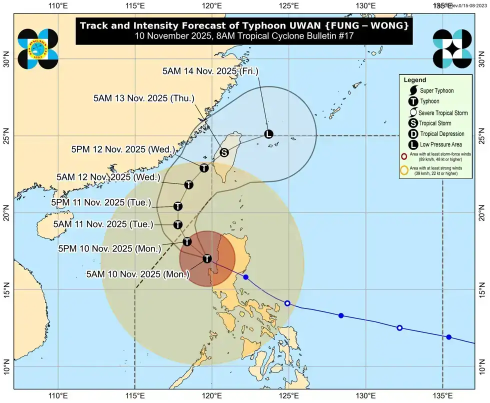
Typhoon Uwan was last reported approximately 125 kilometers west-northwest of Bacnotan, La Union, with maximum sustained winds of 150 kilometers per hour and gusts reaching 185 kph. The storm is moving west-northwest at 20 kph, PAGASA said.
The agency forecasts that Uwan will continue west-northwest or northwest over the next 12 hours, then gradually move northwest to north over the West Philippine Sea, where re-intensification is expected.
By Wednesday, 12 November, Uwan is projected to turn northeast toward the Taiwan Strait, where environmental conditions may cause gradual weakening. PAGASA predicts that the storm’s center will make landfall over western Taiwan by Thursday, 13 November.
Safety Measures and Advisory
Authorities have urged residents in affected areas to:
Secure homes and loose outdoor objects.
Avoid traveling during severe wind and rainfall.
Monitor official updates from PAGASA and local disaster offices.
Prepare evacuation plans in flood-prone or landslide-prone areas.
Officials continue to monitor the storm closely, emphasizing the importance of community preparedness and adherence to local warnings to minimize casualties and damage.
Editorially Reviewed
This article was rewritten and editorially reviewed by Journos News using verified reporting from trusted sources. All content is independently fact-checked and edited for accuracy, neutrality, clarity, and global readability in accordance with the Journos News Editorial Standards.
Opinions, quotes, and statements attributed to contributors, experts, or cited organizations remain those of their respective sources and do not necessarily reflect the views of Journos News. The newsroom maintains full editorial independence from external funders, sponsors, advertisers, and affiliated entities.