Super Typhoon Pepito – Advisory Update (Issued at 08:00 AM, 17 November 2024)
(Valid for broadcast until the next advisory at 11:00 AM today)
Overview
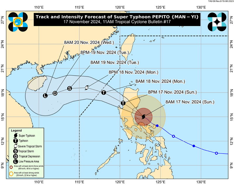
Super Typhoon “Pepito” has passed over the waters north of Calaguas Islands and is now situated over the sea east of Quezon.
Hazards Affecting Land Areas
- Heavy Rainfall Outlook:
Refer to Weather Advisory No. 50 issued at 8:00 AM today for the latest heavy rainfall forecast associated with “Pepito.” - Severe Winds:
The wind signals provide a warning of the general wind threat in areas affected by the tropical cyclone. Winds may be slightly stronger in coastal and upland/mountainous regions exposed to the prevailing winds. Areas sheltered from the wind direction will experience less intensity.- Wind Signal No. 5: Extreme impacts from typhoon-force winds are expected.
- Wind Signal No. 4: Significant to severe impacts from typhoon-force winds are possible.
- Wind Signal No. 3: Moderate to significant impacts from storm-force winds are expected.
- Wind Signal No. 2: Minor to moderate impacts from gale-force winds are likely.
- Wind Signal No. 1: Minimal to minor impacts from strong winds are possible.
- Coastal Inundation:
There is a high risk of life-threatening storm surges, with peak surge heights exceeding 3.0 meters over the next 48 hours. The following areas are at risk:- Ilocos Region (western coast), Isabela, Central Luzon, Metro Manila, CALABARZON, Marinduque, and Bicol Region.
For detailed information, refer to Storm Surge Warning No. 10 issued at 8:00 AM today.
- Ilocos Region (western coast), Isabela, Central Luzon, Metro Manila, CALABARZON, Marinduque, and Bicol Region.
Hazards Affecting Coastal Waters
- Gale Warning:
A Gale Warning is in effect over the eastern, western, and southern seaboards of Luzon and the eastern seaboard of Visayas. For more details, refer to Gale Warning No. 13 issued at 5:00 AM today. - Sea Condition Outlook:
Sea conditions are expected to be very rough, with waves up to 14.0 meters in some areas. Mariners are advised to remain in port or seek shelter until conditions improve.- Very Rough Seas (Up to 14.0m): Northern and eastern seaboards of Polillo Islands; seaboard of Aurora
- High Seas (Up to 12.0m): Seaboard of Camarines Norte
- Rough Seas (Up to 4.0m): Seaboards of Batanes, northern Cagayan (including Babuyan Islands), Zambales
- Moderate Seas (Up to 2.5m): Western seaboard of Bataan; eastern seaboard of Dinagat Islands
Mariners of small vessels are advised not to venture out to sea, especially if inexperienced or operating ill-equipped boats.
Track and Intensity Outlook
- Movement:
PEPITO is expected to continue moving west-northwestward over the waters north of Camarines Provinces and east of Quezon this morning. By late morning, it will pass close to or over Polillo Islands.- Landfall: The typhoon will make landfall over northern Quezon or central/southern Aurora between noon and afternoon today.
- After Landfall: It will cross the northern portion of Central Luzon and the southern portion of Northern Luzon, passing through the upland areas of Sierra Madre, Caraballo, and Cordillera Central by this afternoon and evening.
- Emerging over the West Philippine Sea: PEPITO will emerge over the coastal waters of Pangasinan or La Union tonight or early tomorrow (18 November). It will continue to move generally west-northwestward, and may exit the Philippine Area of Responsibility (PAR) by tomorrow afternoon.
It is important to note that areas outside the forecasted landfall and confidence cone may still experience heavy rainfall, severe winds, and storm surges.
- Intensity:
PEPITO is expected to slightly weaken as it approaches its second landfall. After crossing mainland Luzon, it will likely weaken into a severe tropical storm. Further weakening is expected over the West Philippine Sea due to the incoming northeasterly wind surge.
Current Status
- Location of Eye/Center: The center of PEPITO’s eye is located over the coastal waters of Vinzons, Camarines Norte (14.9°N, 123.1°E).
- Movement: Moving northwestward at 15 km/h.
- Strength: Maximum sustained winds of 185 km/h near the center, with gusts reaching up to 230 km/h.
Conclusion
Residents in affected areas should stay informed and follow advisories issued by local authorities. It is crucial to prepare for heavy rainfall, strong winds, and coastal inundation. Stay indoors and secure property, especially in coastal and highland areas.
Please monitor official weather reports for updates and stay safe.
This article was rewritten by JournosNews.com based on verified reporting from trusted sources. The content has been independently reviewed, fact-checked, and edited for accuracy, neutrality, tone, and global readability in accordance with Google News and AdSense standards.
All opinions, quotes, or statements from contributors, experts, or sourced organizations do not necessarily reflect the views of JournosNews.com. JournosNews.com maintains full editorial independence from any external funders, sponsors, or organizations.
Stay informed with JournosNews.com — your trusted source for verified global reporting and in-depth analysis. Follow us on Google News, BlueSky, and X for real-time updates.