Mount Lewotobi Laki-Laki Erupts Again, Sending Ash Clouds Miles into the Sky
August 2, 2025, 17:00 (U.S. Pacific Time)
Introduction:
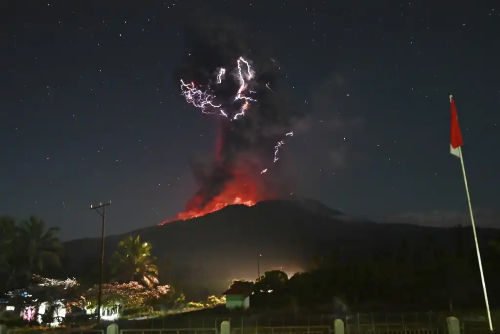
Mount Lewotobi Laki-Laki, one of Indonesia’s most active volcanoes, erupted for the second time in two days, sending massive columns of ash and volcanic debris high into the atmosphere. The eruption has disrupted communities on Flores Island and raised concerns of further volcanic activity amid ongoing geological instability.
Powerful Dual Eruptions Shake Eastern Indonesia
The first eruption occurred Friday evening, producing a dramatic ash column that soared up to 10 kilometers (6.2 miles) into the air. Just hours later, early Saturday morning, a more powerful explosion sent volcanic material as high as 18 kilometers (11 miles), according to Indonesia’s Geological Agency.

Drone surveillance and seismic readings indicated intensified magma movement deep beneath the volcano, triggering multiple tremors. An avalanche of pyroclastic flows—superheated gas mixed with rock and lava—traveled up to 5 kilometers (3 miles) down the mountain slopes, blanketing nearby towns in thick layers of ash and debris.
Villages Covered in Volcanic Debris
Local authorities reported that volcanic material, including hot gravel measuring up to the size of a thumb, was ejected as far as 8 kilometers (5 miles) from the crater. Entire communities were shrouded in ashfall, and roads, rice fields, and rooftops were coated with volcanic residue.
The Geological Agency urged residents to remain vigilant, especially during periods of heavy rainfall, which could cause volcanic mudflows—or lahars—to surge through rivers originating on the mountain. Such flows can be highly destructive and unpredictable.
No Casualties Reported So Far
Despite the intensity of the eruptions, no casualties have been confirmed as of Saturday evening. Emergency response teams have been deployed to assess damage and assist affected communities. Indonesia’s disaster management agency continues to monitor the situation closely.
Residents living within the newly expanded exclusion zone—a 7-kilometer (4.3-mile) radius around the crater—have been advised to evacuate. Authorities had previously placed Mount Lewotobi Laki-Laki under the highest alert level after an earlier eruption on June 18.
A History of Volcanic Activity in the Region
Saturday’s eruption is among the largest recorded in Indonesia since the 2010 Mount Merapi disaster, which claimed over 350 lives and displaced hundreds of thousands. Lewotobi Laki-Laki’s renewed activity adds to a growing list of significant volcanic events in 2025, following a major eruption on July 7 that disrupted flights and blanketed parts of Bali in ash and mud.
The Indonesian government has permanently relocated thousands of people from high-risk zones around Mount Lewotobi following fatal eruptions in November 2023 that killed nine individuals and destroyed numerous homes.
Geological Context: Why Indonesia Faces Constant Volcanic Threats
Indonesia is located along the Pacific “Ring of Fire,” a geologically unstable arc where several tectonic plates meet, making the country highly prone to volcanic eruptions and earthquakes. The nation is home to more than 120 active volcanoes—one of the highest concentrations in the world—and regularly experiences seismic activity.
The island of Flores, where Mount Lewotobi Laki-Laki is situated, is particularly vulnerable due to its proximity to several major fault lines. At 1,584 meters (5,197 feet) tall, the volcano is part of a twin-peaked system that has erupted multiple times over the last century.
Aviation and Agriculture Impact
Although no airports have reported closures from this latest eruption, volcanic ash poses a serious threat to aviation. Ash clouds can damage aircraft engines and reduce visibility, leading to delays or cancellations. The July 7 eruption, for example, disrupted operations at Bali’s Ngurah Rai International Airport, one of the country’s busiest transit hubs.
Agriculture has also been affected. Ashfall can suffocate crops, contaminate water sources, and make soil temporarily infertile. Farmers in the surrounding region have been advised to wear protective gear and avoid working in exposed fields until conditions improve.
Government Response and Public Safety Measures
Indonesia’s National Disaster Mitigation Agency (BNPB) has increased coordination with local governments, volcanologists, and emergency services to manage the evolving situation. Evacuation shelters have been set up, and food, masks, and medical supplies are being distributed to displaced residents.
Public advisories emphasize the importance of adhering to safety protocols, avoiding river valleys prone to lahars, and staying updated through official channels. The agency is also working with meteorological authorities to monitor wind patterns and predict ashfall direction.
Global Monitoring and Research
Volcanologists around the world are closely watching Lewotobi’s activity. The eruptions provide valuable data on magma movement, eruption forecasting, and climate implications, as large volumes of ash and gas in the upper atmosphere can influence regional weather and even contribute to short-term cooling effects.
International cooperation on volcanic monitoring, especially through the Volcanic Ash Advisory Centers (VAACs), ensures that aviation and public safety alerts are disseminated quickly across borders.
Conclusion: Ongoing Vigilance Needed
Mount Lewotobi Laki-Laki’s latest eruptions are a stark reminder of Indonesia’s geological volatility. While no lives have been lost in the most recent events, the situation remains fluid. Authorities continue to urge caution and preparedness as the volcano shows signs of continued instability.
Residents are advised to monitor official updates and remain outside the designated exclusion zones until further notice.
Source: AP News – Indonesia’s Mount Lewotobi Laki Laki erupts again, spewing giant ash plumes miles away